

RealTime Earthquake

RealTime Earthquake ਦਾ ਵੇਰਵਾ
RealTime Earthquake is an information application about earthquakes that occur around you and in the world. RealTime earthquake app using earthquake data from usgs.gov
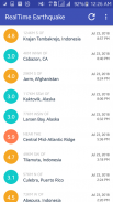
You can see various earthquakes information that already happened, such as the origin of the quake, magnitude, location, time of occurrence, the depth of earthquake, the exact location of the occurrence and the number of reports of people who feel the quake.
RealTime Earthquake application displays a list of earthquakes that can be sorted by time or magnitude and can be set according to the minimum quake magnitude and the limit number of quake data.
Every single information about the earthquake can be seen in detail about the direct map of the earthquake, the official web of the earthquake from USGS, as well as a direct check of tsunami potential through web tsunami.gov from NOAA USGS, you can also share the quake information to your friends.
Features
- User-Friendly
- Real-Time earthquake data
- Using USGS earthquake data
- Refreshable list of the earthquake data
- Sort by earthquake magnitude or time
- Search by quake magnitude
- Setting limit of the earthquake data
- Different color alert for each magnitude
- Origin earthquake detail
- Latitude and Longitude data included
- The depth of the earthquake
- How many people felt the earthquake
- The exact position of the earthquake happened
- Interactive quake map
- Social Sharing for share an earthquake
- USGS Earthquake web detail
- Tsunami Potential from Tsunami.gov


